
 Reply With Quote
Should be in for this.


Due to the November postponement, we're now running the nav run on Sunday January 30th.
This is our first foray into this style of event. You’ll need a car with a full tank of fuel and a working odometer or trip computer (or a GPS that can give you distances), a driver that can follow instructions and a navigator that can give read, interpret and give instructions to the driver! The actual navigation has been set at beginner level with all directions being given out in “tulip map” style, so easy to follow. For those of you wanting to participate, please read the "Tulip Map Basics" below. Start point will be the car park at the western end of E Shed Markets on Victoria Quay in Fremantle at 9am(ie, the opposite end of the same carpark we normally use for "Clint's Coffee Convergence"). Finish location will have food and drinks available for purchase, so don’t forget to bring some spare cash too.
Free For TECCWA members, $10 per car for non members. Confirmed RSVP's to me directly please on [email protected], with a cut off date of January 28th.
Clint
Tulip Map BasicsTulip Maps are individual map instructions indicating the direction to be taken when following a route. When used individually they give directions as to what to do at road junctions given a prescribed distance, and when used in series will guide the vehicle through to an intended destination. To use Tulip Maps, we always assume the vehicle is approaching the map from the bottom of the box. Within that box will then be instructions of which direction to proceed in at the road feature by following the arrow as per the diagram. For ease of use for our upcoming November navigation run, the distances will be in both Kilometres and Miles, and we’ll further break them down to both Individual distances from last instruction, and combined/total distance from the start point. It’s worth taking notes as you travel along the route – street names and landmarks, in case you get lost and need to make your way back part way. Typically, navigation stages directed by Tulip Maps will also give an instruction for every road junction encountered, even if it does not alter the cars intended direction – for example side streets passed. When considering the upcoming TECCWA Navigation Run on November 13th - due to the fact that the course was set by road map and recollection 2500Kms away from the event location and not an actual transverse of the course – not every road junction is mapped – only those that require an action other than driving straight ahead are listed. This both reduces the number of Tulip Maps to be read, and makes the navigation easier for our inaugural navigation event, so should have no negative impact on the day.
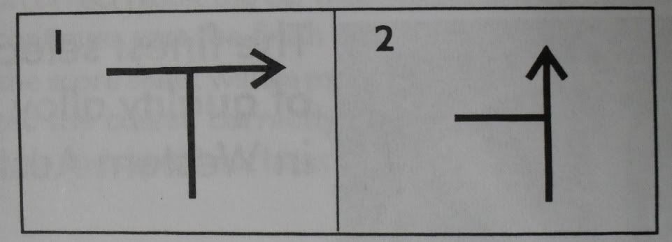
To give a couple of simple examples above, the Tulip map on the left indicates a right turn at a T junction. The Tulip Map on the right indicates maintaining the current course as you pass a road on the left. Developing from those maps, the next set of nine maps as shown:
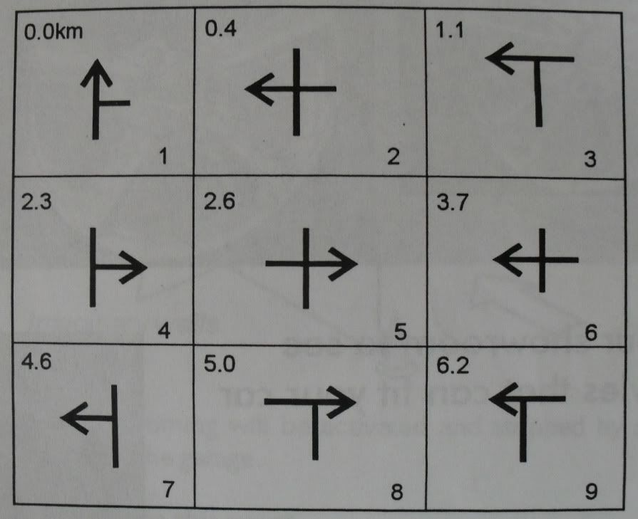
Gives the following instructions:
1. Start Navigation and pass a road on the right
2. At 0.4Kms turn left at the crossroads
3. At 1.1Kms turn left at the T Junction
4. At 2.3kms turn right onto the side road
5. At 2.6Kms turn right at the crossroads
6. At 3.7Kms turn left at the crossroads
7. At 4.6Kms turn left into the side road
8. At 5.0Kms turn right at the T Junction
9. At 6.2Kms turn left at the T Junction
Official Distance
Official Distance is a measure by which the navigation course has been set. It may be accurate to a measurement (for example - Metres) or may be innacurate either by desire or necessity. In setting the Nav Run for November, I have also driven the course to determine the distance recordings. I chose to do this my TA63 Celica and the trip meter in that car - the accuracy of that trip meter is levelled out by providing you with an official distance by which you can determine any error factor needed for your car. Usually only one Official Distance route is given, however in an attempt to familiarise you all with this new format, I have provided several which you can test out prior to the event.
The official distances for this navigation run are:
E Shed Markets, Fremantle: Start point is the give way line exiting the carpark at the western end. Turn left onto Victoria Quay Rd, then immediately left into Cliff St. Follow Cliff Street and turn left into Phillimore St. Continue past James St (on RHS) and take your next left turn into Victoria Quay Gate 2. Travel along Victoria Quay Rd then enter the E Shed Markets Carpark on left. Stop point is the first pedestrian crossing you pass in the car park. This distance is 3.0Kms
Leach Hwy, Willeton to Bull Creek: Start point is the white stop line at the traffic lights at High Road. Travel West along Leach Highway till the white stop line of the traffic lights at Bull Creek Dr, Bull Creek. This distance is 2.2Kms.
Leach Hwy, Winthrop to O'Connor: Start point is the white stop line at the traffic lights at Murdoch Drive. Travel West along Leach Highway till the white stop line of the traffic lights at Stock Road, O'Connor. This distance is 4.9Kms
High Road, Fremantle: Start point is the white stop line at the traffic lights at Carrington Street. Travel West along High Road till the white stop line of the traffic lights at Stirling Highway. This distance is 1.5Kms
Marine Pde, Cottesloe: Start point is the white give way line at the Eric Street instersection (ie, approach along Eric St and turn left onto Marine Pde). Travel South along Marine Parade till the give way line at the roundabout on Curtin Ave. This distance is 2.8Kms
Once you have traversed any of the official distance checks you will have two distance figures - the official distance, and your car's distance. To ensure you follow the navigation accurately, you then take your car's distance and divide it by the official distance, to give you an error figure, which you can then apply (error factor multiplied by official distance given at a particular point - to show you the distance your car's odometer/trip computer will read at that point too) to any official distance given to ensure you can reference distances with your car's odometer/trip computer. Don't forget to bring a calulator! Once you have your head around error calculations, you can also use them to correct any actual navigation errors you make on the day, without resetting your trip computer too.
With your new found navigation skills, we look forward to seeing you at the January Nav Run!
Last edited by CLG; 26-01-2011 at 11:06 PM.
Should be in for this.
1977 RA35 Celica GT - I4 | 2007 GSV40R Aurion - V6
Don't live life being scared of death, live in the fear of not truly living. RP 2012
sounds like fun, ill go providing the beastie is here which it should bebryce can navigate
The bird of Hermes is my name eating my wings to make me tame.
__________________________________________________ _
RA23 - 1G-GTE
Very much interested,
Pending axel build though...
-A
Four Cam Inside The VG30DET+T powered MA61.. actually running, really it is!, no wait its broken again...
The Lithium Ion Powered Sera EV Conversion, Getting some upgrade love.
Latest member: The AW11 MR2 'Trouble'
280ZX Now with RD28 Turbo conversion. Actaully finished!
I should be free
SPIDA - 1974 TA22 Celica (2TGEU 1600cc with Garrett GT25 320HP turbo) Dyno - 168.9HP at 10PSI, 14.8 sec quarter (so far)
TECCWA Member | Drag Run Videos
I can't understand these friggin maps - so I'm happy to help with a check point again
Damo
83 GA61 Toyota Supra XX [TRD 83] - 7MGTE Turbo-A inside
83 KE70 Toyota Corolla - the budget build
94 EF Ford Fairmont Ghia [FATFORD] - looks tough, goes slow
64 Chev Impala - west coast lowrider
good news the beast gets here tomorrow so as long as the pits dont give me shit it shall be a winner
The bird of Hermes is my name eating my wings to make me tame.
__________________________________________________ _
RA23 - 1G-GTE
Any more participants - need to get an idea of how many maps will be needed for the day?
Up in the bush sorry
The bird of Hermes is my name eating my wings to make me tame.
__________________________________________________ _
RA23 - 1G-GTE
I'll be there in the Mazda with Christian navigating.
I just did a distance check today, down in Cottesloe, and think your wording for the checking an odometer against the official distance might be wrong.
For example, the official distance for the Cottesloe test is 2.8km. When I drove it, our odometer said 2.7km.
Your instruction says to divide the official distance (2.8) by our car distance (2.7) to get an error factor. That is, 2.8/2.7 which would give 1.037.
However, this seems wrong to me, as I'd think it should be 2.7/2.8 to give 0.964.
Therefore, any 100km official distance would show as 96.4km on my trip meter as opposed to 103.7km using the method you said.
Is my method correct and yours wrong? Or am I missing something?
Gene
SPIDA - 1974 TA22 Celica (2TGEU 1600cc with Garrett GT25 320HP turbo) Dyno - 168.9HP at 10PSI, 14.8 sec quarter (so far)
TECCWA Member | Drag Run Videos
Yep, you are correct Gene - my mistake sorry. Truth be known, whenever I nav - I usually do a few calculations to double check stuff - got my wording wrong on this occasion and will correct the first post now.
May i recommend canceling as an account of rain... quite a lot of rain??
http://www.bom.gov.au/products/IDW60281.shtml
Let me know if you do cancel it Clint. FYI, Christian will be going in a car with Mum, and I'll be with Jenelle, so we'll be there in 2 cars, weather permitting.
Gene
SPIDA - 1974 TA22 Celica (2TGEU 1600cc with Garrett GT25 320HP turbo) Dyno - 168.9HP at 10PSI, 14.8 sec quarter (so far)
TECCWA Member | Drag Run Videos
I'm going to keep the event on. If we get down to Freo and the weather is catastrophic, we'll do a coffee meet instead - as per last time.
Yep, definately on and definately being run. According to the BOM website, the cyclone/low pressure system is rapidly weakening and will not cross the coast till after 6pm - we'll be run and done around 1-2pmish.
 Posting Permissions
Bookmarks